Transport for London with Emacs org-mode
Here is how I integrated the Transport for London API in Emacs. Enjoy!
Motivation
I've moved to London in February. Some would say it's not London, it's Greater London. The commute is about 50 minutes to work including walking. Back in Stuttgart my trains would only run every half an hour so I had to plan every journey to minimise my layover. I was afraid it would be the same in London, and since I don't know the tube that well, I decided to plan in advance.
The Transport for London website is already very nice. But I have a regular schedule
and I don't want to type in the same input each day just to check my trains.
Also org-mode became more and more part of my daily workflow.
The agenda view is awesome and I wanted my commute to show up there.
At that time I was very new to lisp/emacs-lisp. It sometime took me 20 minutes to find out how to manipulate some of the data structures. But in the end I learned a lot and now I can't stop writing silly Emacs packages.
Transport for London API
That was actually a big surprise. The API is simply awesome! Yes, you can plan journeys. But there is actually much more. 344 traffic cams are available, live! You can get a xml file with all of them listed.
<syndicatedFeed>
  <header>
    <identifier>TfL Traffic Cameras</identifier>
    <version>0.1</version>
    <publishDateTime>2016-04-24T11:18:11Z</publishDateTime>
    <author>digital@tfl.gov.uk</author>
    <owner>Transport for London</owner>
    <refreshRate>1</refreshRate>
    <max_Latency>10</max_Latency>
    <timeToError>10</timeToError>
    <overrideMessage/>
    <errorMessage/>
    <feedInfo/>
    <logo>http://www.tfl.gov.uk/tfl-global/images/roundel.gif</logo>
  </header>
  <cameraList updated="1461493091">
    <rooturl>/tfl/livetravelnews/trafficcams/cctv/</rooturl>
    <camera id="00001.01251" available="true">
      <corridor>-</corridor>
      <location>Old Street e of Vince St</location>
      <currentView>Test</currentView>
      <file>00001.01251.jpg</file>
      <captureTime>2016-04-24T10:15:21Z</captureTime>
      <easting>532787</easting>
      <northing>182600</northing>
      <lat>51.5262</lat>
      <lng>-0.08563</lng>
      <osgr>TQ328826</osgr>
      <postCode/>
    </camera>
  </cameraList>
</syndicatedFeed>
Combining the rooturl with a file from the camera will get you a link like:
https://tfl.gov.uk/tfl/livetravelnews/trafficcams/cctv/00001.01251.jpg

Figure 1: Live traffic camera footage
There is a nice interactive API explorer site. What I needed was the journey planner API. There are a lot of parameters but what you essentially need is something like this:
https://api.tfl.gov.uk/Journey/JourneyResults/Bank/to/Westminster
This will try to retrieve a journey from Bank to Westminster. The problem is that TfL knows way more than one Bank or Westminster station. It will return a response with something like a 300 status code and a disambiguation result: For each location type (to, from, via) there is a list with possible candidates. The user has to select one of each and then you send a new request with the more precise information.
{
  "$type": "Tfl.Api.Presentation.Entities.JourneyPlanner.DisambiguationResult, Tfl.Api.Presentation.Entities",
  "toLocationDisambiguation": {
    "$type": "Tfl.Api.Presentation.Entities.JourneyPlanner.Disambiguation, Tfl.Api.Presentation.Entities",
    "disambiguationOptions": [
      {
        "$type": "Tfl.Api.Presentation.Entities.JourneyPlanner.DisambiguationOption, Tfl.Api.Presentation.Entities",
        "parameterValue": "1000266",
        "uri": "\/journey\/journeyresults\/bank\/to\/1000266",
        "place": {
          "$type": "Tfl.Api.Presentation.Entities.StopPoint, Tfl.Api.Presentation.Entities",
          "naptanId": "HUBWSM",
          "modes": [
            "tube"
          ],
          "icsCode": "1000266",
          "stopType": "stop",
          "url": "https:\/\/api-neon.tfl.gov.uk\/StopPoint\/HUBWSM",
          "commonName": "Westminster (London), Westminster",
          "placeType": "StopPoint",
          "additionalProperties": [],
          "lat": 51.50139978595,
          "lon": -0.12490128591
        },
        "matchQuality": 1000
      },
      {
        "$type": "Tfl.Api.Presentation.Entities.JourneyPlanner.DisambiguationOption, Tfl.Api.Presentation.Entities",
        "parameterValue": "1002085",
        "uri": "\/journey\/journeyresults\/bank\/to\/1002085",
        "place": {
          "$type": "Tfl.Api.Presentation.Entities.StopPoint, Tfl.Api.Presentation.Entities",
          "naptanId": "930GWMR",
          "modes": [
            "river-bus"
          ],
          "icsCode": "1002085",
          "stopType": "stop",
          "url": "https:\/\/api-neon.tfl.gov.uk\/StopPoint\/930GWMR",
          "commonName": "Westminster (London), Westminster Pier",
          "placeType": "StopPoint",
          "additionalProperties": [],
          "lat": 51.50181087832,
          "lon": -0.12361646769000001
        },
        "matchQuality": 967
        }
    ],
    "matchStatus": "list"
  },
  "fromLocationDisambiguation": {
    "$type": "Tfl.Api.Presentation.Entities.JourneyPlanner.Disambiguation, Tfl.Api.Presentation.Entities",
    "disambiguationOptions": [
      {
        "$type": "Tfl.Api.Presentation.Entities.JourneyPlanner.DisambiguationOption, Tfl.Api.Presentation.Entities",
        "parameterValue": "1000013",
        "uri": "\/journey\/journeyresults\/1000013\/to\/westminster",
        "place": {
          "$type": "Tfl.Api.Presentation.Entities.StopPoint, Tfl.Api.Presentation.Entities",
          "naptanId": "HUBBAN",
          "modes": [
            "dlr",
            "tube"
          ],
          "icsCode": "1000013",
          "stopType": "stop",
          "url": "https:\/\/api-neon.tfl.gov.uk\/StopPoint\/HUBBAN",
          "commonName": "City of London, Bank",
          "placeType": "StopPoint",
          "additionalProperties": [],
          "lat": 51.513389043480004,
          "lon": -0.08882541444
        },
        "matchQuality": 1000
      },
      {
        "$type": "Tfl.Api.Presentation.Entities.JourneyPlanner.DisambiguationOption, Tfl.Api.Presentation.Entities",
        "parameterValue": "51.66151925957,-0.09419500928",
        "uri": "\/journey\/journeyresults\/51.66151925957,-0.09419500928\/to\/westminster",
        "place": {
          "$type": "Tfl.Api.Presentation.Entities.Place, Tfl.Api.Presentation.Entities",
          "url": "https:\/\/api-neon.tfl.gov.uk\/Place\/",
          "commonName": "Bankside, Enfield (London)",
          "placeType": "StopPoint",
          "additionalProperties": [],
          "lat": 51.66151925957,
          "lon": -0.09419500927999999
        },
        "matchQuality": 964
      }
     ],
    "matchStatus": "list"
  },
  "viaLocationDisambiguation": {
    "$type": "Tfl.Api.Presentation.Entities.JourneyPlanner.Disambiguation, Tfl.Api.Presentation.Entities",
    "matchStatus": "empty"
  },
  "recommendedMaxAgeMinutes": 1440,
  "searchCriteria": {
    "$type": "Tfl.Api.Presentation.Entities.JourneyPlanner.SearchCriteria, Tfl.Api.Presentation.Entities",
    "dateTime": "2016-04-24T11:32:00",
    "dateTimeType": "Departing"
  },
  "journeyVector": {
    "$type": "Tfl.Api.Presentation.Entities.JourneyPlanner.JourneyVector, Tfl.Api.Presentation.Entities",
    "from": "Bank",
    "to": "Westminster",
    "via": "",
    "uri": "\/journey\/journeyresults\/bank\/to\/westminster"
  }
}
The issue is, that for stops you would need to send the icsCode and for others the latitude and longitude data.
I discovered that you can always take the latitude and longitude data for an unambiguous result.
The only issue is that the journey will always include a 10m - 50m walk at the beginning and end.
I noticed that sometimes emacs wouldn't call my callback after the response was received.
It just got stuck waiting for more from the server.
After activating the url-http-debug mode, I noticed that this happens with 300s status codes.
url-retrieve will get stuck in "Spinning waiting for headers", which never
completes so the callback is never called.
The url-http-parse-headers function doesn't handle the 300 status code, well.
So I had to override the function to simply set success to t for said status code.
Curiously at first it still worked randomly without that fix.
Now once you request your journey with unique locations you get a proper result back:
{
  "$type": "Tfl.Api.Presentation.Entities.JourneyPlanner.ItineraryResult, Tfl.Api.Presentation.Entities",
  "journeys": [
    {
      "$type": "Tfl.Api.Presentation.Entities.JourneyPlanner.Journey, Tfl.Api.Presentation.Entities",
      "startDateTime": "2016-04-24T12:57:00",
      "duration": 13,
      "arrivalDateTime": "2016-04-24T13:10:00",
      "legs": [...]
    },
    {
      "$type": "Tfl.Api.Presentation.Entities.JourneyPlanner.Journey, Tfl.Api.Presentation.Entities",
      "startDateTime": "2016-04-24T12:58:00",
      "duration": 13,
      "arrivalDateTime": "2016-04-24T13:11:00",
      "legs": [...]
    },
    {
      "$type": "Tfl.Api.Presentation.Entities.JourneyPlanner.Journey, Tfl.Api.Presentation.Entities",
      "startDateTime": "2016-04-24T13:02:00",
      "duration": 12,
      "arrivalDateTime": "2016-04-24T13:14:00",
      "legs": [...]
    }
  ],
  "lines": [...],
  "recommendedMaxAgeMinutes": 4,
  "searchCriteria": {...},
  "journeyVector": {...}
}
The intersting parts are the journeys and especially their legs list.
Also lines can is usefull to get information about disruption.
So with this list of journeys we already know when to leave and when we arrive.
But we don't know how to get there.
That's where legs become important. They provide very indepth information.
"legs": [
        {
          "$type": "Tfl.Api.Presentation.Entities.JourneyPlanner.Leg, Tfl.Api.Presentation.Entities",
          "duration": 5,
          "instruction": {
            "$type": "Tfl.Api.Presentation.Entities.Instruction, Tfl.Api.Presentation.Entities",
            "summary": "Jubilee line to London Bridge",
            "detailed": "Jubilee line towards Stratford, or North Greenwich",
            "steps": []
          },
          "obstacles": [...],
          "departureTime": "2016-04-24T12:57:00",
          "arrivalTime": "2016-04-24T13:02:00",
          "departurePoint": {...},
          "arrivalPoint": {...},
          "path": {...},
          "routeOptions": [...],
          "mode": {...},
          "disruptions": [...],
          "plannedWorks": [],
          "isDisrupted": true,
          "hasFixedLocations": true
        },
        ...
      ]
So here we actually get not only instructions generated for us, but also a list of obstacles (e.g. elevator is out of order), the path with exact geo locations, disruptions and planned work information and more.
It's only a matter of parsing the information and presenting it to the user.
Org Mode
Links
org-mode has a great feature for links. Depending on the protocol (e.g. http or file) in the url
org-mode uses a different handler function and you can extend those with your own link types.
I added a handler for org-tfl: links.
(org-add-link-type "org-tfl" 'org-tfl-jp-open-org-link)
The handler function simplified looks like this:
(defun org-tfl-jp-open-org-link (&optional path)
  "Open a org-tfl link.  PATH is ignored.  Properties of the paragraph are used instead."
  (let* ((element (org-element-at-point))
   (FROM (org-element-property :FROM element))
   (TO (org-element-property :TO element))
   (VIA (org-element-property :VIA element))
   (SCHEDULED (org-get-scheduled-time (point))))
    (when SCHEDULED
      (setq DATE (format-time-string "%Y%m%d" SCHEDULED))
      (setq TIME (format-time-string "%H%M" SCHEDULED)))
    (org-tfl-jp-retrieve-org
     FROM TO :via VIA :date DATE :time TIME)))
This assumes that the link is part of a heading and the paragraph has some special properties. I have a nother function which writes these links and properties automatically.
\*\* Retrieving Information...
  SCHEDULED: <2016-04-24 So 13:59>
  :PROPERTIES:
  :FROM:     Picadilly Circus
  :TO:       Liverpool Street
  :TIMEIS:   Departing
  :END:
Once all the results are retrieved, I come back to the opened link, and replace the link description, paragraph and properties with the parsed result.
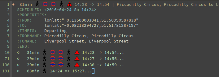
The link can be opened again to update the result.
Icons
All icons are svg which are inserted via text properties. I collected loads of those svg icons and had to modify them by hand. Most of the time it's a simple resize. Emacs can edit svgs in plain text. They are like xml.
<?xml version="1.0" encoding="iso-8859-1"?>
<svg xmlns="http://www.w3.org/2000/svg" width="18" height="20" viewBox="0 0 640 520">
  <title>London DLR</title>
  <g stroke="#009999" fill="none">
    <circle cx="320" cy="260" r="215" stroke-width="90"/>
  </g>
  <g stroke="#0019a8" fill="none">
    <path d="M 0,260 H 640" stroke-width="100" />
  </g>
</svg>
To resize an image, it's best to add the viewBox attribute with the original size.
Then you can easily adjust height and width to your liking without having to worry about
positioning or aspect ratio.
The downside is, that the images and icons don't scale at the moment. So it only works for one font and font size.
Now when you have the path to an svg or png image file, all you need to insert it in a buffer is:
(insert
 (propertize "  " 'display
  (create-image
   (with-temp-buffer (insert-file-contents "path/to/image.svg") (buffer-string))
   'svg t :ascent 80 :mask 'heuristic)))
The string can be an alternate string for when you don't display images. But it should have roughly the same
width as the image for best results.
The ascent of 80 was perfect for my font size.
The mask value heuristic is needed to make transparency work.
Underground Line Color
TfL has a very well thought out corporate style guide. Every color is well defined for each
use-case.
You can read the full specification here.
I wanted to make the tube line names highlighted with their respective color.
This can be done by adding font-lock keywords.
First you need a faces with the right colors and a mapping to their names. Then you add it to the keywords:
...

(defface org-tfl-waterloo-face
  '((t (:foreground "white" :background "#66CCCC")))
  "Waterloo and City Line Face"
  :group 'org-tfl)

(defvar org-tfl-line-faces
  '(("Bakerloo line" 0 'org-tfl-bakerloo-face prepend)
    ("Central line" 0 'org-tfl-central-face prepend)
    ("Circle line" 0 'org-tfl-circle-face prepend)
    ("District line" 0 'org-tfl-district-face prepend)
    ("Hammersmith & City line" 0 'org-tfl-hammersmith-face prepend)
    ("Jubilee line" 0 'org-tfl-jubliee-face prepend)
    ("Metropolitan line" 0 'org-tfl-metropolitan-face prepend)
    ("Northern line" 0 'org-tfl-northern-face prepend)
    ("Piccadilly line" 0 'org-tfl-piccadilly-face prepend)
    ("Victoria line" 0 'org-tfl-victoria-face prepend)
    ("Waterloo and City line" 0 'org-tfl-waterloo-face prepend))
  "Mapping of lines to faces.")

(font-lock-add-keywords 'org-mode org-tfl-line-faces t)
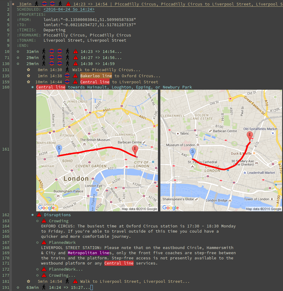
Maps
What's really cool about the TfL API are the paths with exact geo locations. You can use those to draw a map. If you have access to the google maps api, you could create a route and give the user a link to an interactive map. But in Emacs we need static images. Luckily the google maps API also features static maps. All you need is a crafted url with all the geo positions. The positions have to be concatenated with the pipe character. The first and last positions should be used as marker positions.
https://maps.google.com/maps/api/staticmap?size=800x800&maptype=roadmap&path=color:0xff0000ff|weight:5|51.51538417456,-0.14134847217|51.51558212527,-0.13965411967&markers=label:S|color:blue|51.51538417456,-0.14134847217&markers=label:E|color:red|51.51558212527,-0.13965411967
You can either insert that link in as an org link or download the picture to a temp location and create a link to that temp file. This enables inline images.
Careful though. The link can only be roughly around 2000 characters long. For long paths you have to split them up and create several links.
Final Result
Turns out the tfl package can be really useful. The headings show up in your agenda view and allow for a quick check for when you have to leave. I made it available on melpa and of course github.
Now turns out, after a week you know your commute and trains go every 2 minutes, so I actually don't use it anymore.
The same concept could be applied to other public transportation APIs or the Google Maps API. This would make it available for a broader audience. Anyway I learned a lot and it was quite fun.